Geospatial data analyst creates tool to raise awareness of extreme heat and flooding in the region
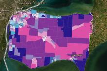
With temperatures rising across Windsor-Essex County this week, Leddy Library’s geospatial data analyst, Carina Luo, designed a web application to raise awareness about climatic hazards in the area, particularly flooding and extreme heat.
After completing research about climate trends in the region, Luo found that Windsor-Essex holds the record for the greatest number of annual heat waves in Ontario between 1971 and 2000. In addition, inland floods have also been a consistent problem for the region, with significant flooding events occurring in 2016, 2017, and 2020.
After completing research about climate trends in the region, Luo found that Windsor-Essex holds the record for the greatest number of annual heat waves in Ontario between 1971 and 2000. In addition, inland floods have also been a consistent problem for the region, with significant flooding events occurring in 2016, 2017, and 2020.
Connect with your library