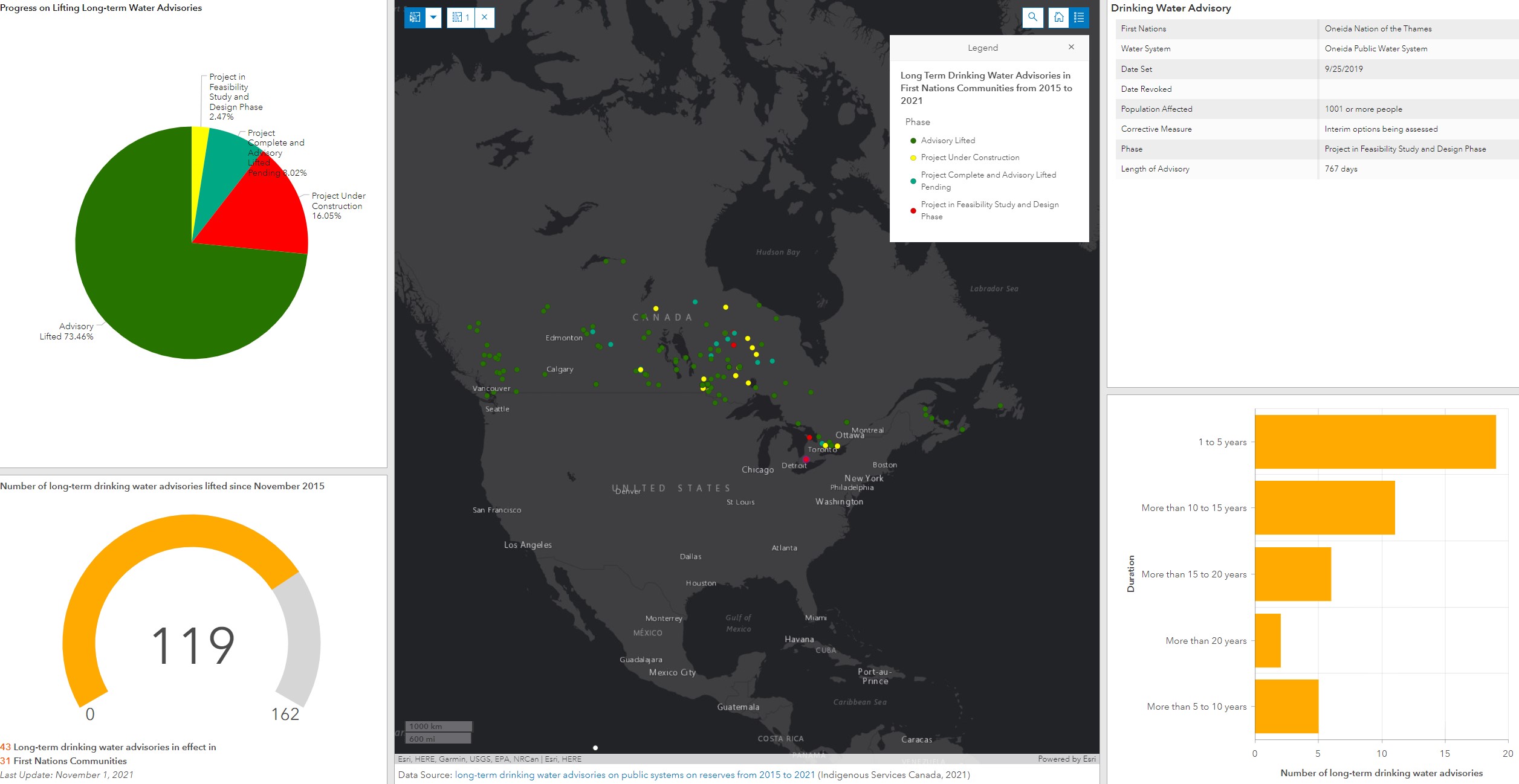
While libraries across Canada celebrate geographic information systems Nov. 17 as GIS Day, Leddy Library’s geospatial data analyst Carina Luo decided to use the technology to raise awareness about the ongoing water crisis in First Nation communities.
“Access to safe and reliable drinking water is easy for most Canadians, however many First Nations communities have long been experiencing challenges to accessing safe drinking water,” said Luo, who provides geospatial services to the campus community through the Academic Data Centre.
As of Nov. 1, there were a total of 99 drinking water advisories in effect in First Nations communities across Canada, according to the most recent data available at the time of Luo’s study.
An expert in the field of GIS, Luo collected data and used Esri StoryMap, an online GIS platform that allows researchers to combine interactive maps with text, photos, videos and other multimedia content, to create The Water Crisis in Canada's First Nations Communities: Examining the progress towards eliminating long-term drinking water advisories in Canada.
The resource presents the water crisis in a spatial context to visualize the locations of drinking water advisories across Canada and uses statistical and visual tools to summarize the advisory data in terms of their duration, advisory type, size of population affected.
“While research is still emerging, there are significant gaps in the knowledge of multi-dimensional impacts of drinking water crisis that go beyond physical illness to affect the economy as well as the social and cultural health of First Nations in Canada,” said Luo. “There are little longitudinal and systematic studies of drinking water and Indigenous communities across Canada.”
GIS technologies have proven to be highly effective for performing site selection, detecting patterns and relationships hidden in the data, understanding changes over time, and making predictions.
“The true power of GIS lies in its capability to perform spatial analysis — a process in which you examine problems geographically to better understand our world,” said Luo. “Answering important questions like where things are, how they relate, what it all means, and what actions to take.”
Luo hopes the resource can increase people’s awareness of the long-standing issue of inadequate access to safe drinking water in First Nations communities across Canada, noting that it is important to acknowledge that the water crisis is also reflective of and compounded by the underlying economic, social, political marginalization, and disadvantages faced by First Nations peoples of Canada.
The application also helps to track progress on the government’s promise to end drinking water advisories on public systems on reserves.
“I hope this research can provide evidence to advocate for the government to expand its efforts from solely monetary investments towards a broader, evidence-based, and multi-faceted approach that can addresses issues related the underlying social, economic, and environmental factors that affect water provision, safety, and quality in First Nations communities.”

Connect with your library