GIS Day is held worldwide during Geography Awareness Week, November 17-23, 2013. As part of the celebration, the Academic Data Centre is hosting a GIS exhibit entitled "Discover Food Deserts in Windsor" running Friday, November 8 to Friday, November 22 in the Leddy Library.
“Food deserts” can be described as geographic areas where residents have little or no access to healthy and affordable foods due to the absence of large grocery stores within convenient travelling distance1. Residents living in these food deserts – especially elderly people or those with low-income who often lack a vehicle or depend on public transportation, tend to consume less nutritious, processed foods readily available at corner stores and fast-food restaurants2. This will inevitably impact their dietary choices and, ultimately, increase their likelihood of developing obesity, diabetes, cardiovascular disease and other diet-related health problems3. Previous Canadian research has identified serious food deserts in Toronto, Saskatoon, Kingston and London4.
Do “food deserts” also exist in Windsor? Come and discover how Geographic Information Systems (GIS) are being used to better understand our local food environments.
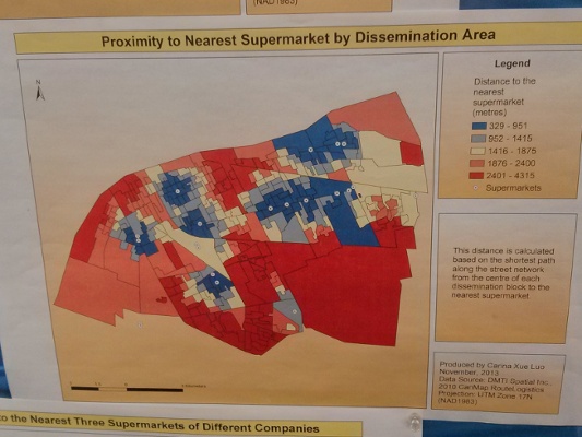
The exhibit will showcase the mapping of the distribution of grocery stores within the city and whether they are accessible as created by Carina Xue Luo, the Geospatial Data Analyst at the Academic Data Centre. Using ArcGIS Software, she plotted the locations of Windsor's supermarkets and calculated each neighbourhood's access to the stores using the actual street network. She also used census information about income, age, ethnicity and vehicle ownership to identify high-need neighbourhoods where residents are most vulnerable to limited access to nutritious foods — low-income, senior, visible minority and those without a vehicle. Through this approach, she identified several potential food deserts — socio-economically disadvantaged neighbourhoods with little or no access to large supermarkets.
Attendees will have the opportunity to learn about the geospatial resources and technologies used to create the maps and to understand how GIS can enhance our ability to research the interplay between human behaviors and their environments.
For more information on this exhibit, please contact:
Carina Xue Luo Geospatial Data Analyst
Tel: (519) 253-3000 ext. 3179 E-mail: carina@uwindsor.ca
1 http://www.foodispower.org/food-deserts/
2 Smoyer-Tomic, K. E., Spence, J. C., and Amrhein, C. (2010). Food deserts in the Prairies? Supermarket accessibility and neighbourhood need in Edmonton, Canada. The Professional Geographer, 58(3), 307-326.
3 http://www.ehatlas.ca/built-environments/food-deserts
4 http://reurbanist.com/2011/11/food-deserts-in-canadian-cities-prevent-revitalization/
Connect with your library