Topography Map | DEM | Bathymetry
Topography Map
CanMatrix - Digital Topographic Maps of Canada
Natural Resources Canada, 1996
Scanned topographic maps (raster) of Canada based on the National Topographic System (NTS) 1:50,000 and 1:250,000 scale paper maps published by Natural Resources Canada. The files are geocoded according to NAD83 and have a scanned resolution of 300 dpi.
Format: GeoTIFF (.tif)
Access: Download form GeoGraits Geospatial Product Index
CanVec+
Natural Resource Canada, 2011
A new digital vector dataset replacing the National Topographic Data Base (NTDB). Data contain more than 90 topographic entities thematically organized into 11 distribution themes: Administrative Boundaries, Buildings and Structures, Energy, Hydrography, Industrial and Commercial Areas, Places of Interest, Relief and Landforms, Toponymy, Transportation, Vegetation and Water Saturated Soils.
Format: ESRI Shapefiles
Access: Download from GeoGraits Geospatial Product Index
National Topographic Data Base (NTDB)
Natural Resources Canada, 1998
Digital vector data sets that cover the entire Canadian landmass. Each data set consists of one NTS unit at either the 1:50,000 or 1:250,000 scale. Coverages include the following 13 themes: hydrography, hypsography (contours), vegetation, the road network, roads, the rail network, the electric power network, designated areas, landform and relief, water saturated soils, toponymy and manmade features.
Format: ESRI Shapefiles
Access: Download from GeoGraits Geospatial Product Index
CanTopo
New generation of topographic maps at a scale of 1:50,000.
Formats: PDF, TIFF, GeoTIFF, GeoPDF.
Access: Download from GeoGratis
Canadian Atlas Map Bundle (CAMB)
DMTI Spatial Inc., 2005
National and provincial level topographic data based on the National Atlas Information Service (NAIS) 1:2 million, 1:7.5 million, and 1:30 million scale digital maps. The NAIS 1:2 million-scale dataset provides detailed provincial or regional map data. The 1:7.5 and 1:30 million scale digital datasets provide excellent map data at a national level. It offers many more name attributes (for physical features, populated places and roads) than most other digital boundary files.
Format: MapInfo, ESRI Shapefiles
Access: Request from ADC
Digital Elevation Model (DEM)
Canadian Digital Elevation Model [Ed. 3.0]
Natural Resources of Canada, 2007
DEM tiles covering all areas of Canada, based on the NTS 1:50 000 and 1:250 000 scale maps. Data are provided in USGS DEM format, and must be converted into raster format before they can be viewed in ArcGIS.
Format: ASCII files (.dem)
Access: Download from GeoGraits Geospatial Product Index
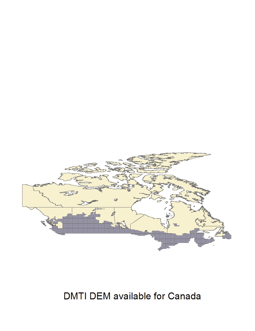
DMTI Digital Elevation Model (DEM)
DMTI Spatial Inc., 2011
DEM tiles covering most of Canada at the 1:50,000 (30m resolution) and 1:250,000 (90m resolution) scale. Index shows DEM coverage available through DMTI. Data are provided in ASCII .txt format, and must be converted into raster format before they can be viewed in ArcGIS.
Format: ASCII files (.dem), Planet (UTM projection only) files
Access: Request from ADC
More Info: Data Description (University of Waterloo)
Bathymetry
Bathymetry of Lake Ontario
National Geophysical Data Center, NOAA Great Lakes Environmental Research Lab, NOAA National Ocean Service, Canadian Hydrographic Service, 1999
Access: Download from the National Centers for Environmental Information
Bathymetry of Lake Erie and Lake Saint Clair
National Geophysical Data Center, NOAA Great Lakes Environmental Research Lab, NOAA National Ocean Service, Canadian Hydrographic Service, 1999
Access: Download from the National Centers for Environmental Information
Bathymetry of Lake Michigan
National Geophysical Data Center, NOAA Great Lakes Environmental Research Lab, NOAA National Ocean Service, Canadian Hydrographic Service, 1996
Access: Download from the National Centers for Environmental Information
Connect with your library